
-
Research Article
-
Analyzing Content Articulation in the 2022 Revised Elementary and Middle School Social Studies Geography Curriculum
2022 개정 초·중학교 사회과 지리교육과정의 내용 연계성 분석
-
Dongkyun Han
한동균
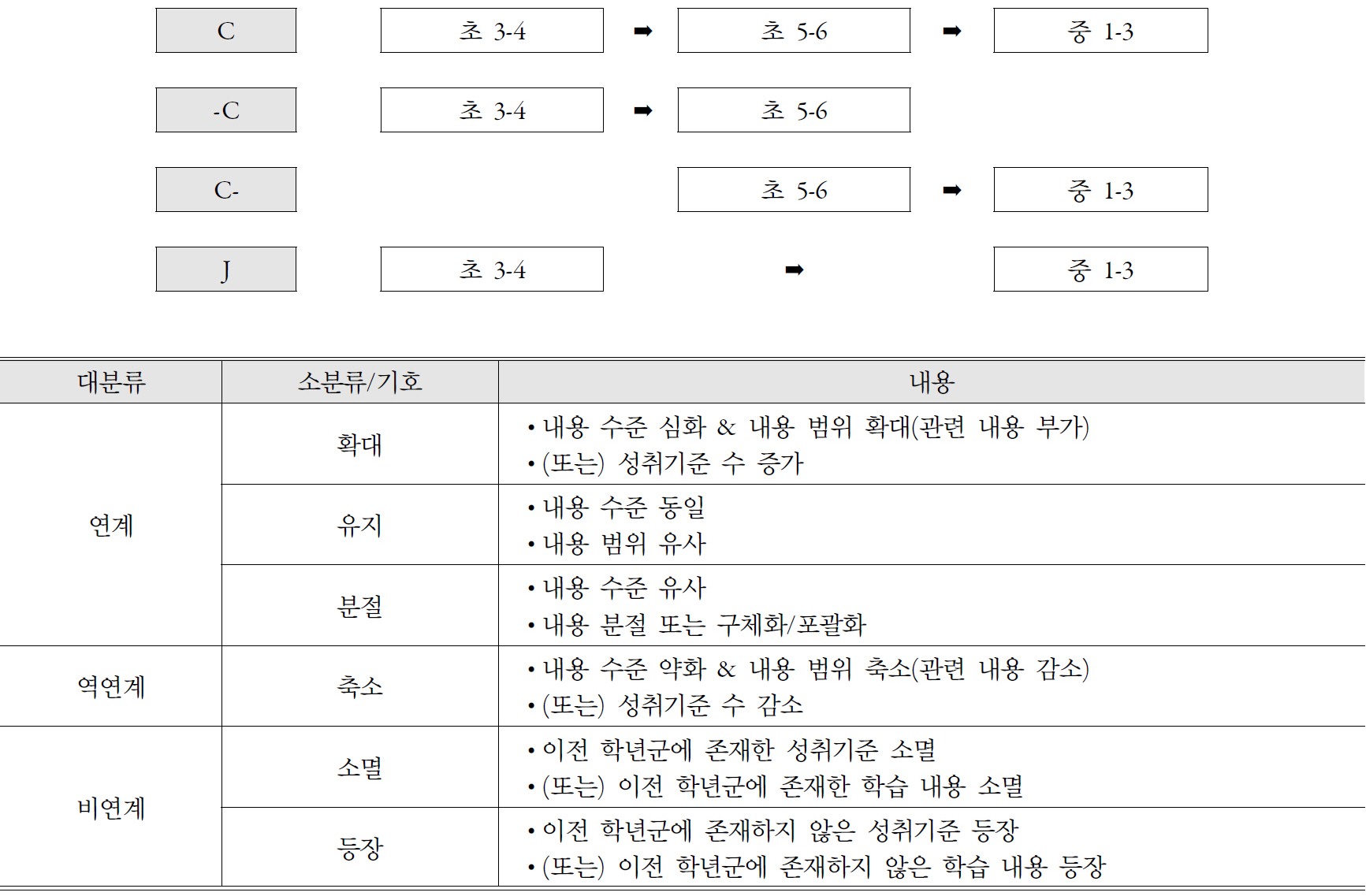
- This study aims to analyze content articulation across grade bands and school levels in the geography curriculum of the 2022 revised social …
본 연구는 2022 개정 사회과 지리교육과정의 학년군 및 학교급 간 내용 연계성을 분석하는 데 목적이 있다. 이를 위해 초등학교 3~4학년군, 5~6학년군, 중학교 …
- This study aims to analyze content articulation across grade bands and school levels in the geography curriculum of the 2022 revised social studies curriculum. To this end, geography-related achievement standards for elementary grades 3–4, elementary grades 5–6, and middle school grades 1–3 were examined. The analysis focused on the arrangement patterns of achievement standards and types of content articulation, using key ideas and the subcategories of knowledge and understanding as analytical frameworks. The findings show that the 2022 revised social studies geography curriculum was generally designed with consideration of articulation across school levels; however, the actual patterns of articulation differed depending on the content elements. “Location and territory,” “Spatial analysis,” “Climatic environment,” “Geomorphological environment,” “Human–environment interaction,” “Population,” and “Sustainable environment” showed relatively stable expanding-sequence patterns of articulation. In contrast, “Place and region,” “Culture,” “Urban and rural settlements,” and “Economy and transportation” tended to be attenuated or become less explicitly represented in elementary grades 5–6 and then reappear as analytically elaborated concepts in middle school. In addition, “Sustainable world” was mainly addressed in upper elementary grades and middle school, showing a mixed patterns of emergence and expansion. These findings suggest that the issue of articulation in the 2022 revised social studies geography curriculum is not simply a matter of whether achievement standards appear across grade bands. Rather, it is closely related to the differing principles of content organization between theme-based geography learning in elementary school and regional geography-centered learning in middle school. In particular, the domain of human environments and human life revealed a likelihood of conceptual leap due to the lack of intermediary learning experiences in the upper elementary grades before students encounter middle school regional geography. Based on these findings, this study derives implications for the organization of and articulation within elementary and middle school social studies geography curricula. This study is significant in that it analyzes articulation in the 2022 revised social studies geography curriculum and identifies specific gaps and patterns of content continuity and articulation across elementary and middle school levels. However, because the analysis was based primarily on achievement standards and their accompanying curriculum commentary, it has limitations in fully identifying content-level articulation that is not explicitly represented in curriculum documents. Future research should incorporate textbooks, teaching and learning materials, and actual classroom cases to comprehensively examine how curriculum articulation is actually implemented in school contexts.
- COLLAPSE
본 연구는 2022 개정 사회과 지리교육과정의 학년군 및 학교급 간 내용 연계성을 분석하는 데 목적이 있다. 이를 위해 초등학교 3~4학년군, 5~6학년군, 중학교 1~3학년군의 지리 관련 성취기준을 대상으로, 핵심 아이디어와 지식·이해의 하위 범주를 기준으로 성취기준 배열 양상과 내용 연계 유형을 분석하였다. 2022 개정 사회과 지리교육과정은 전반적으로 학교급 간 연계성을 고려하여 구성되어 있었으나, 실제 연계 양상은 내용 요소에 따라 상이하게 나타났다. ‘위치와 영역’, ‘공간분석’, ‘기후환경’, ‘지형환경’, ‘자연-인간의 상호작용’, ‘인구’, ‘지속가능한 환경’은 비교적 안정적인 확대형 계열성을 보인 반면, ‘장소와 지역’, ‘문화’, ‘도시와 촌락’, ‘경제와 교통’은 초등학교 5~6학년군에서 관련 내용이 약화되거나 명시적으로 드러나지 않다가 중학교에서 분석적 개념으로 재등장하는 양상을 보였다. 또한 ‘지속가능한 세계’는 초등학교 고학년과 중학교에서 주로 다루어지며, 대체로 등장과 확대가 혼합된 연계 양상을 보였다. 이러한 결과는 2022 개정 사회과 지리교육과정의 연계성 문제가 단순히 성취기준의 출현 여부가 아니라, 초등학교의 주제 중심 지리 학습과 중학교의 지역지리 중심 학습 사이의 내용 조직 원리 차이와 관련되어 있음을 보여준다. 특히 인문환경과 인간 생활은 초등학교 고학년의 매개 학습이 부족하여 중학교 지역지리 학습과의 개념적 도약이 발생할 가능성이 확인되었다. 이러한 분석 결과를 바탕으로 초·중학교 사회과 지리교육과정의 내용 조직과 연계 보완을 위한 시사점을 도출하였다. 본 연구는 2022 개정 사회과 지리교육과정의 연계성을 분석하고, 초·중학교급 간 내용의 공백과 연계 양상을 구체적으로 드러냈다는 점에서 의의를 갖는다. 하지만 본 연구는 교육과정 문서에 제시된 성취기준과 해설을 중심으로 분석한 것이므로, 문서상 표면적으로 드러나지 않는 내용적 연계성까지 충분히 파악하는 데에는 한계가 있다. 향후 연구에서는 교과서, 교수·학습 자료, 실제 수업 사례 등을 함께 분석하여 교육과정 문서상의 연계성이 학교 현장에서 실제로 어떻게 구현되는지를 종합적으로 검토할 필요가 있다.
-
Analyzing Content Articulation in the 2022 Revised Elementary and Middle School Social Studies Geography Curriculum
-
Research Article
-
A Study on Elementary School Teachers’ Conceptual Ecologies of Regionalization - Focusing on Lather’s Notion of ‘Getting Lost’ -
초등 교사들의 지역화에 대한 개념생태 연구 - Lather의 ‘길 잃음’의 의미를 중심으로 -
-
Jiyoung Lee · Sangjoon Nam · JungHyang Na · Hyejeong Jang
이지영 · 남상준 · 나정향 · 장혜정
- This study explores teachers’ conceptual ecologies in regionalization in elementary social studies. Four teachers from a district office of education in Seoul …
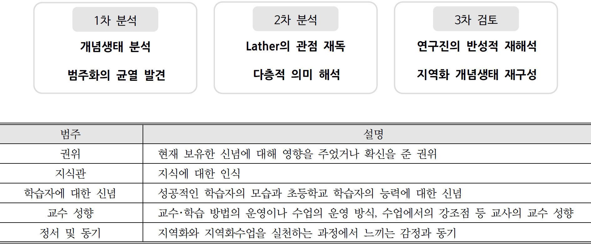
이 연구의 목적은 초등사회과 지역화에 대한 교사들의 개념생태를 파악하는 것이다. 이 연구에서는 서울의 한 교육지원청에 근무하는 4인의 교사들을 참여자로 선정하여 면담을 진행하고 …
- This study explores teachers’ conceptual ecologies in regionalization in elementary social studies. Four teachers from a district office of education in Seoul were interviewed, and their responses were analyzed qualitatively. The findings showed that the teachers initially provided similar answers using curriculum-related terminology, but their perspectives gradually diverged. These differences were shaped by personal experiences, educational philosophies, understandings of students, and local contexts, producing interpretations that were difficult to integrate into a single framework. The teachers’ conceptual ecologies of regionalization were found to be context-dependent and continuously reconstructed through practice. Although the researchers initially expected to identify relatively stable and coherent conceptual ecologies, the interviews revealed moments of hesitation, uncertainty, and conflicting justifications within and across teachers’ responses. Their understandings of regionalization were not fixed, but dynamically formed within their own ecological contexts. Rather than resolving or integrating these differences into a unified interpretation, this study presents the teachers’ conceptual ecologies in their divergent and unresolved forms. The findings suggest that understanding how teachers interpret and practice regionalization requires attention to the dynamic process through which meaning is constructed within the relationship between researchers and participants. The study ultimately calls for expanded opportunities for such dialogic engagement in regionalization research and, more broadly, in geography education research.
- COLLAPSE
이 연구의 목적은 초등사회과 지역화에 대한 교사들의 개념생태를 파악하는 것이다. 이 연구에서는 서울의 한 교육지원청에 근무하는 4인의 교사들을 참여자로 선정하여 면담을 진행하고 발화를 분석하였다. 연구 결과는 다음과 같다. 연구 참여 교사들은 지역화에 대하여 처음에는 교육과정의 용어를 사용하면서 유사한 답변을 하다가 점차 서로 다른 방향으로 분기하였다. 이 분기는 개인적 경험, 교육철학, 지역의 상황에 기반한 것으로서 하나로 종합하기 어려운 고유성을 지니고 있었다. 지역화에 대한 교사들의 개념생태는 수업 속에서 맥락 의존적이며 지속적으로 재구성되는 실천이었다. 연구진은 면담에서 안정적이고 일관된 지역화 개념생태를 발견할 것이라 기대했으나 흔들림, 망설임, 상반된 근거들이 공존하는 장면을 발견하였다. 개념은 고정되지 않았고, 각자의 생태에서 다르게 구성되고 있었다. 연구진은 독특하고 다양하며, 서로 다른 방향으로 분기하고 있는 교사들의 개념생태에 대하여 교사들 간의 차이를 통합하지 않고 해결되지 않은 상태로 제시하는 방식을 택하였다. 교사들이 지역화를 어떻게 이해하고 실천하는지를 파악하기 위해서는, 연구자와 참여자가 서로 얽힌 관계 속에서 의미를 공동으로 구성하는 과정에 대한 고려가 필요하다. 지역화, 나아가 지리교육의 연구에서 이러한 얽힘의 기회가 적극적으로 확대·창출되기를 기대한다.
-
A Study on Elementary School Teachers’ Conceptual Ecologies of Regionalization - Focusing on Lather’s Notion of ‘Getting Lost’ -
-
Research Article
-
Changes in Elementary School Students’ Peace and Unification Sensitivity and Place Representations of the Korean Peninsula through a Peer Tutoring-Based Peace and Unification Project
또래교수 학습 중심의 평화·통일 프로젝트에 참여한 초등학생의 평화·통일 감수성과 한반도 장소 표상 변화
-
Kanghee Lee
이강희
- This study examined changes in elementary school students’ peace and unification sensitivity and place representations of the Korean Peninsula through a peer …
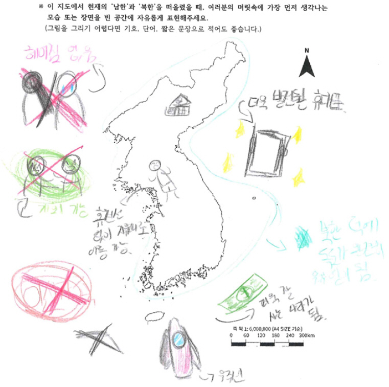
본 연구는 또래교수 학습 중심의 평화·통일 프로젝트에 참여한 초등학생의 평화·통일 감수성과 한반도 장소 표상 변화 양상을 분석하였다. 이를 위해 부산광역시 A 초등학교 …
- This study examined changes in elementary school students’ peace and unification sensitivity and place representations of the Korean Peninsula through a peer tutoring-based peace and unification project. The participants were 48 fifth-grade students in Busan who worked with sixth-grade tutors. Survey responses, mental maps, and open-ended responses were analyzed quantitatively and qualitatively. The results showed significant improvements in overall peace and unification sensitivity, unification awareness, relational perception, and perception of peace and unification agency, while pluralistic and peaceful perception showed no significant change. Qualitative findings indicated that students’ representations partially expanded from disconnectedness and otherness toward connectedness, coexistence, and mobility. These findings suggest that CAPT (cross-age peer tutoring)-based peace and unification projects grounded in a relational view of place can serve as a practical approach in elementary geography education for linking students’ peace and unification sensitivity with their place representations of the Korean Peninsula.
- COLLAPSE
본 연구는 또래교수 학습 중심의 평화·통일 프로젝트에 참여한 초등학생의 평화·통일 감수성과 한반도 장소 표상 변화 양상을 분석하였다. 이를 위해 부산광역시 A 초등학교 5학년 학생 48명을 대상으로 6학년 학생을 튜터로 연결한 상급학생 또래교수 학습 기반 프로젝트 학습을 실시하고, 평화·통일 감수성 설문, 한반도 심상지도, 서술형 응답 자료를 정량적·정성적으로 분석하였다. 분석 결과, 전체 평화·통일 감수성과 통일 인식, 관계론적 인식, 평화·통일 실천성 인식은 정량적으로 유의하게 향상되었으나, 다원적·평화적 인식은 유의한 차이를 보이지 않았다. 질적 자료에서는 사전의 단절성·타자성 중심 표상이 사후에 연결성·공존성·이동성을 포함하는 관계적 장소 표상으로 일부 확장되었다. 다만 이러한 변화는 기존 표상의 완전한 해소라기보다 관계적 장소 표상의 추가·확장으로 해석된다. 본 연구는 관계론적 장소관에 기반한 상급학생 또래교수 학습 중심의 평화·통일 프로젝트가 초등 지리교육에서 평화·통일 감수성과 한반도 장소 표상을 함께 다루는 실천적 평화·통일 교육 방안이 될 수 있음을 시사한다.
-
Changes in Elementary School Students’ Peace and Unification Sensitivity and Place Representations of the Korean Peninsula through a Peer Tutoring-Based Peace and Unification Project
-
Research Article
-
An Analysis of the Alignment of ‘Map Elements’ Learning in Elementary Social Studies and Directions for Geographical Education Reconstruction
초등 사회과 ‘지도의 요소’ 학습의 정합성 분석 및 지리교육적 재구성 방향 모색
-
HyunJu Kim
김현주
- This study analyzed the manifestation of ‘map elements’ learning design principles from the 2022 Revised Social Studies Curriculum in authorized textbooks and …
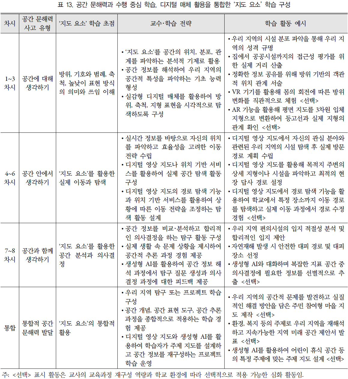
본 연구는 2022 개정 사회과 교육과정의 ‘지도의 요소’ 학습 설계 원리가 검정 교과서에 구현된 양상을 분석하고 지리교육적 재구성 방향을 모색하였다. 이를 위해 …
- This study analyzed the manifestation of ‘map elements’ learning design principles from the 2022 Revised Social Studies Curriculum in authorized textbooks and explored directions for geographical educational reconstruction. To this end, eight authorized textbooks were systematically reviewed using Bowen’s qualitative document analysis and Webb’s alignment model. The analysis revealed that while external curriculum guidelines were faithfully followed, qualitative limitations such as fragmented learning and the use of decontextualized geographical materials were present in terms of the depth and structure of knowledge. Additionally, the use of digital media was found to be concentrated on specific elements. Consequently, this study proposed performance-centered wayfinding activities to foster spatial literacy and suggested expanding media into digital environments. This research holds educational significance by providing a practical basis for improving the quality of future textbook development and instructional design.
- COLLAPSE
본 연구는 2022 개정 사회과 교육과정의 ‘지도의 요소’ 학습 설계 원리가 검정 교과서에 구현된 양상을 분석하고 지리교육적 재구성 방향을 모색하였다. 이를 위해 Bowen의 질적 문헌 분석과 Webb의 정합성 분석 모델을 적용하여 8종의 검정 교과서를 체계적으로 검토하였다. 분석 결과, 교육과정의 외형적 지침을 충실히 반영하였으나 지식의 깊이와 구조적 측면에서 분절적 학습과 탈맥락화된 소재 활용이라는 질적 한계를 보였으며 디지털 매체 활용이 특정 요소에 편중되었음을 확인하였다. 이에 본 연구는 공간 문해력 함양을 목적으로 하는 수행 중심의 길 찾기 활동과 디지털 환경으로의 매체 확장을 제안하였다. 본 연구는 향후 교과서 개발 및 교수․학습 설계의 질적 제고를 위한 실질적 근거를 제공한다는 점에서 교육적 의의를 지닌다.
-
An Analysis of the Alignment of ‘Map Elements’ Learning in Elementary Social Studies and Directions for Geographical Education Reconstruction
-
Research Article
-
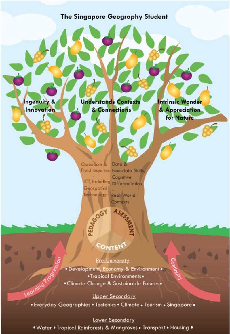
Analysis of the Singaporean Geography Curriculum Centered on Sustainability - Focus on the 2022/23 Secondary and Pre-University Syllabus -
지속가능성을 중심으로 한 싱가포르 학교지리의 설계와 그 특징 - 2022/23년 적용 중등 및 중등 이후(대학 전) “Syllabus” 분석을 중심으로 -
-
JaYeon Yang
양자연
- This study investigates the design characteristics of a sustainability-centred school geography curriculum through an analysis of the Singaporean secondary geography curriculum under …
본 연구에서는 ‘과목 기반 수준제’라는 새로운 교육제도에서 적용되고 있는 싱가포르 중등 지리교육과정의 분석을 통해, 지속가능성을 중심으로 한 학교지리의 교육과정 설계 사례로서 그 …
- This study investigates the design characteristics of a sustainability-centred school geography curriculum through an analysis of the Singaporean secondary geography curriculum under the new Full Subject-Based Banding (Full SBB) system. Methodologically, a literature review of geography syllabi and assessment criteria at the secondary and pre-university levels was conducted, complemented by semi-structured interviews with two members of the Syllabus Development Committee. The findings are as follows: First, the revised curriculum exhibits structural integration where geography curriculum concepts, learning progressions, and continuity are systematically organised around the central theme of sustainability. Second, contemporary challenges related to sustainable development serve as the primary criteria for content selection, specifically focusing on water resources, tropical climates, tourism, and urban environments—areas also emphasised in the Singapore Green Plan. Third, the curriculum provides explicit conceptual definitions and maps to visualise the flow between concepts. Furthermore, it presents a progressive sequence of questions that guides students from a representational understanding to a critical evaluation of sustainability issues, promoting an inquiry-based approach.
- COLLAPSE
본 연구에서는 ‘과목 기반 수준제’라는 새로운 교육제도에서 적용되고 있는 싱가포르 중등 지리교육과정의 분석을 통해, 지속가능성을 중심으로 한 학교지리의 교육과정 설계 사례로서 그 특징을 밝히는 것을 목적으로 한다. 이를 위해 새로운 싱가포르 중등 교육제도에서 진행 중인 중등 및 중등 이후(대학 전) 교육과정의 지리 교육과정과 각각의 교육과정을 평가하는 평가 기준을 분석 대상으로 한 문헌분석과 이를 보완하기 위한 싱가포르 교육과정 개발 위원회 회원 중 2인을 대상으로 반구조화 인터뷰를 진행하였다. 그 결과, 첫째, 싱가포르의 새롭게 개정된 중등 및 중등 이후(대학 전) 과정에는 지속가능성을 중심으로 지리 커리큘럼 개념과 지리 학습 발달과정, 연속성이 교육과정이 제시되는 구조적 특징을 갖는다. 둘째, 싱가포르는 지리학습의 내용 선정에 있어서 지속가능성 및 지속가능한 발전을 학습할 수 있는 물과 열대기후(수자원), 관광(경제), 도시에 관한 현대적 과제가 내용 선정의 주요 기준이 된다. 이는 싱가포르의 지속가능한 발전을 주도하는 ‘그린 플랜’에서도 강조되는 과제들이 선정되고 있음을 알 수 있었다. 셋째, 지속가능성의 명확한 개념 정의 및 개념도, 용어 정의 및 출처, 그리고 지속가능성에 대해 점진적으로 탐구할 수 있도록 질문이 제시되고 있음을 알 수 있었다.
-
Analysis of the Singaporean Geography Curriculum Centered on Sustainability - Focus on the 2022/23 Secondary and Pre-University Syllabus -
-
Research Article
-
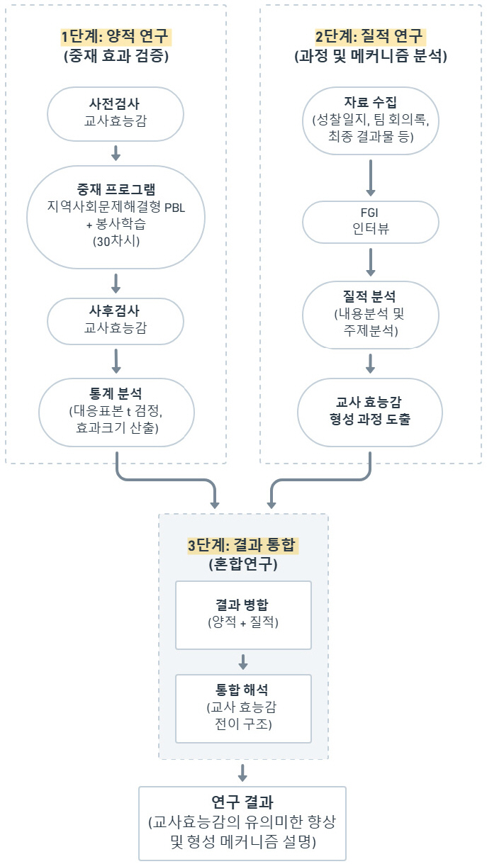
Impact of Community-Engaged Project-Based Service Learning on Pre-Service Teachers' Teaching Efficacy - A Convergent Mixed Methods Study -
지역사회 연계 PjBL 봉사학습이 예비교원의 교사효능감 형성에 미치는 영향 - 수렴적 혼합연구 -
-
Bo Ae Chun · Eunjin Nam · Jin-Kyu Jung · Santiago Lopez
전보애 · 남은진 · 정진규 · 산티아고 로페즈
- This study explored the effects of a service learning program implemented within a community problem-solving project-based learning (PjBL) environment on changes in …
본 연구는 지역사회 문제해결형 프로젝트 기반 학습(PjBL) 환경에서 운영된 봉사학습 프로그램이 예비 지리교원의 교사효능감 변화에 미치는 영향을 수렴적 혼합연구방법으로 탐색하였다. 강원특별자치도 강릉시 …
- This study explored the effects of a service learning program implemented within a community problem-solving project-based learning (PjBL) environment on changes in pre-service geography teachers' teacher efficacy, employing a convergent mixed methods design. Twenty pre-service geography teachers participated in a 30-session service learning program centered on the Namdaecheon River in Gangneung, Gangwon State, which was selected for its distinctive ecological and community characteristics. Data were collected through pre- and post-teacher efficacy assessments, 229 reflective journals, and in-depth interviews. Quantitative analysis revealed statistically significant improvements in both general teacher efficacy (d=.82) and context-specific teacher efficacy (d=.84). Qualitative analysis identified four core themes: the awakening of reflective teaching awareness, growth of practical teaching competence through autonomous practice, reconstruction of local ecological knowledge, and the gradual formation of professional teacher identity through mentor-mentee interaction. Convergent integration analysis confirmed a stage-based developmental trajectory [χ2(2, N=211)=9.99, Cramer’s V=.22]. These findings suggest that a structured community-based PjBL service learning program effectively promotes both general and context-specific teacher efficacy in pre-service teachers.
- COLLAPSE
본 연구는 지역사회 문제해결형 프로젝트 기반 학습(PjBL) 환경에서 운영된 봉사학습 프로그램이 예비 지리교원의 교사효능감 변화에 미치는 영향을 수렴적 혼합연구방법으로 탐색하였다. 강원특별자치도 강릉시 남대천을 대상지로 한 총 30차시의 봉사학습에 참여한 예비 지리교원(n=20)을 대상으로 사전·사후 교사효능감 검사와 교육봉사일지 및 심층 인터뷰 분석을 병행하였다. 양적 분석 결과, 대응표본 t-검정에서 일반 교사효능감(d=0.82)과 특수 교사효능감(d=0.84) 모두 통계적으로 유의하게 향상되었다. 질적 분석에서는 교수자 자아의 각성, 자율적 실천을 통한 교수 역량의 성장, 지역 생태 지식의 재구성, 멘토-멘티 상호작용을 통한 교직 정체성 형성의 네 가지 핵심 주제가 도출되었다. 수렴적 통합 분석을 통해 교사효능감이 활동 단계에 따라 일반 교사효능감 중심에서 특수 교사효능감 중심으로, 이후 두 유형의 균형 상태로 전이하는 단계적 발달 경로가 확인되었다[χ2(2, N=211)=9.99, Cramer’s V=.22]. 본 연구는 이론-현장-통합의 단계적 구조를 갖춘 지역사회 연계 PjBL 봉사학습이 예비교원의 일반 교사효능감과 맥락 특수적 교사효능감을 순차적·상호 보완적으로 증진시키는 효과적 교육 방법임을 시사한다.
-
Impact of Community-Engaged Project-Based Service Learning on Pre-Service Teachers' Teaching Efficacy - A Convergent Mixed Methods Study -
-
Research Article
-
Development of a Place-Based Geomorphology and Environmental Education Program to Connect Students’ Lives with Their Local Environment
학생 삶과 연계를 위한 장소기반 지형환경교육 프로그램 개발 - 경기도 광주시 경안천을 중심으로 -
-
Sarang Kang · Jongmin Byun
강사랑 · 변종민
- In the context of accelerating climate change and urbanization, environmental issues highlight the growing importance of education that helps students understand local …
오늘날 기후변화와 도시화로 인한 재해 및 환경 문제는 지역의 지형과 환경을 이해하는 교육의 중요성을 더욱 부각시키고 있다. 그러나 학교 현장의 지형교육은 여전히 …
- In the context of accelerating climate change and urbanization, environmental issues highlight the growing importance of education that helps students understand local geomorphological and environmental conditions. However, geomorphology education in schools still remains largely conceptual and detached from students’ lived spaces and local environmental problems. Responding to this gap, this study aimed to develop a place-based geomorphology and environmental education program that enables students to understand regional geomorphological and environmental issues within the context of their daily lives, while fostering ecocentric values and a sense of responsibility as ecological citizens. This study demonstrates a shift in geomorphology education from abstract knowledge transmission toward region-based, practice-oriented inquiry. It offers a concrete pathway for school geography education to connect students’ learning with their lived experiences and local communities.
- COLLAPSE
오늘날 기후변화와 도시화로 인한 재해 및 환경 문제는 지역의 지형과 환경을 이해하는 교육의 중요성을 더욱 부각시키고 있다. 그러나 학교 현장의 지형교육은 여전히 개념 전달에 머물러 있으며, 학생이 생활하는 지역의 환경 문제와 연계성이 부족하다. 이러한 문제의식 속에서 본 연구는 학생들이 지역의 지형과 환경 이슈를 자신 삶의 맥락 속에서 이해하고 생태중심주의적 가치관을 함양하는 장소기반 지형환경교육 프로그램을 개발하고 그 교육적 의미를 탐색하였다. 프로그램 적용 결과, 학습자들은 장소 인지와 환경 감수성 측면에서 향상된 모습을 보였으며, 지역 문제를 공공적 관점에서 재해석하고 생태 시민으로서의 실천 의지를 형성하였다. 본 연구는 지형교육을 추상적 지식 전달에서 지역 기반의 실천적 탐구로 전환한 사례로서, 학교 지리교육이 학습자의 삶과 지역사회를 연결하는 구체적 경로를 제시하였다. 또한 개발된 장소기반 지형환경교육 프로그램이 우리나라 도시화 지역에서 빈번히 발생하는 홍수와 수질오염 문제를 중심으로 다루고 있기 때문에 지역의 특수성을 넘어 보편적으로 적용될 수 있는 환경교육의 방향성을 제시한다는 점에서도 의의를 갖는다.
-
Development of a Place-Based Geomorphology and Environmental Education Program to Connect Students’ Lives with Their Local Environment
-
Research Article
-
Reviewing the Appropriateness of Regional Geographic Education in the College of Education Curriculum and Exploration of Alternatives
사범대학 교육과정에서 지역지리교육의 적절성 검토와 대안 모색
-
Sungwook Cho
조성욱
- In this study, the appropriateness of regional geography education in the curriculum of geography education at the College of Education was examined, …
이 연구에서는 사범대학 지리교육과 교육과정에서 지역지리교육의 적절성을 살펴보고, 대안을 모색했다. 이를 위해 초중등학교와 사범대학 교육과정을 분석하고, 사범대학에서 지역지리교육의 방향성을 4가지 측면에서 논의했다. …
- In this study, the appropriateness of regional geography education in the curriculum of geography education at the College of Education was examined, and alternatives were sought. To this goal, the curriculum of elementary and secondary schools and universities was analyzed, and the direction of regional geographic education in the College of Education was discussed in four aspects. First, in terms of setting the goal and level of regional geography, geography teachers need to a higher level of understanding and perspective on the region than the general public as a regional expert. Second, for regional geographic education, a didactic transposition is required from systematic geography to regional geography contents. Third, it is necessary to strengthen the professionalism of graduates of the College of Education by further subdividing the region of regional geography subjects. Fourth, as a teaching-learning method for regional geography subjects, it seems appropriate to give a small group or individual assignment presentation classes along with an overall overview by a lecturer who has formed a perspective on the region. Currently, regional geography education exists as an incidental or trace subject in the university curriculum, and in order for geography teachers as experts in regional geography, it is necessary to subdivide regional geography subjects and improve their expertise accordingly.
- COLLAPSE
이 연구에서는 사범대학 지리교육과 교육과정에서 지역지리교육의 적절성을 살펴보고, 대안을 모색했다. 이를 위해 초중등학교와 사범대학 교육과정을 분석하고, 사범대학에서 지역지리교육의 방향성을 4가지 측면에서 논의했다. 논의 내용은 첫째, 지역지리의 목표와 수준 설정 측면에서 지리교사는 지역의 전문가로서 일반인에 비해서 더 높은 수준의 지역 이해와 지리적 관점을 형성할 필요가 있다. 둘째, 지역지리교육을 위해서는 계통지리 내용을 지역지리 내용으로 교수학적 변환 과정이 필요하다. 셋째, 지역지리 과목의 지역을 더 세분화하여 사범대학 졸업생들의 전문성을 강화할 필요가 있다. 넷째, 지역지리 과목의 교수-학습 방법은 지역에 대한 관점을 형성한 강의자에 의한 전체적인 개관과 함께 소집단 또는 개인별 과제 발표 수업이 적절하다. 현재 사범대학 교육과정에서 지역지리교육은 부수적인 과목으로 존재하고 있으며, 지리교사를 지역지리교육의 전문가로 양성하기 위해서는 지역지리 과목의 세분화와 그에 따른 전문성 제고가 필요하다.
-
Reviewing the Appropriateness of Regional Geographic Education in the College of Education Curriculum and Exploration of Alternatives
-
Research Article
-
Metaverse-Based Learning Experiences and Changes in Pre-Service Geography Teachers’ Dispositions Toward the Use of EdTech and Geospatial Technologies
메타버스를 활용한 학습경험과 예비 지리교사의 에듀테크 및 지리정보기술 활용 성향 변화
-
Jinhee Lee
이진희
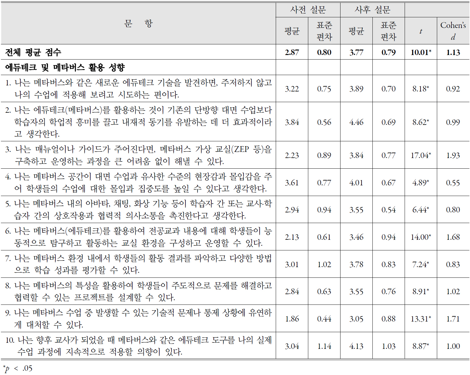
- This study explores changes in pre-service geography teachers’ dispositions toward the use of EdTech and geospatial technologies after they designed metaverse-based teaching …
본 연구는 메타버스를 활용한 교수·학습 모형 설계 및 수업 실연 경험 이후 예비 지리교사의 에듀테크 및 지리정보기술 활용 성향에 어떠한 변화가 나타나는지를 …
- This study explores changes in pre-service geography teachers’ dispositions toward the use of EdTech and geospatial technologies after they designed metaverse-based teaching and learning models and conducted teaching demonstrations. To this end, pre- and post-surveys and focus group interviews were conducted with 63 pre-service geography teachers from 2023 to 2025. The results showed a relatively clear positive change in their dispositions toward EdTech use, along with a significant change in their dispositions toward geospatial technology use. Focus group interview data served as supplementary evidence suggesting that these changes were associated with accumulated practical experience in lesson design and teaching demonstrations.
- COLLAPSE
본 연구는 메타버스를 활용한 교수·학습 모형 설계 및 수업 실연 경험 이후 예비 지리교사의 에듀테크 및 지리정보기술 활용 성향에 어떠한 변화가 나타나는지를 탐색하는 데 목적이 있다. 이를 위해 2023년부터 2025년까지 3개년에 걸쳐 예비 지리교사 63명을 대상으로 사전·사후 설문조사와 포커스 그룹 인터뷰를 실시하였다. 연구 결과, 메타버스를 활용한 교수·학습 모형 설계 및 수업 실연 경험 이후 예비 지리교사의 에듀테크 활용 성향에서는 비교적 뚜렷한 긍정적 변화가 관찰되었으며, 지리정보기술 활용 성향에서도 유의한 변화가 나타났다. 포커스 그룹 인터뷰 자료는 이러한 변화가 실제 수업 설계와 실연을 포함한 실천적 경험의 축적과 관련이 있음을 보여주었다.
-
Metaverse-Based Learning Experiences and Changes in Pre-Service Geography Teachers’ Dispositions Toward the Use of EdTech and Geospatial Technologies

Journal Informaiton
 The Journal of The Korean Association of Geographic and Environmental Education
The Journal of The Korean Association of Geographic and Environmental Education


한국지리환경교육학회
(06639) 96 Seochojungang-ro, Seocho-gu, Seoul (1650 Seocho-dong) Seoul National University of Education
Tel: +82-2-3475-2436 / E-mail: kageeedit@naver.com Copyright© The Korean Association Of Geographic And Environmental Education. Powered by APUB
Tel: +82-2-3475-2436 / E-mail: kageeedit@naver.com Copyright© The Korean Association Of Geographic And Environmental Education. Powered by APUB