
-
Research Article
-
A Backward Approach to Activating Primary Geography Education - Focusing on the Teachers’ Voices -
초등지리교육의 활성화를 위한 후향적 접근 - 교사의 목소리를 중심으로 -
-
Sangjoon Nam · Jiyoung Lee · HyunJu Kim
남상준 · 이지영 · 김현주
- This study explores strategies to revitalize primary geography education by strengthening its identity and systematization. Adopting a backward approach that values teachers’ …
본 연구의 목적은 정체성과 체계성을 기반으로 한 초등지리교육의 활성화를 도모하기 위한 방안을 탐색하는 것이다. 본 연구는 현장적합성 높은 방안의 탐색을 위하여 교사들의 …
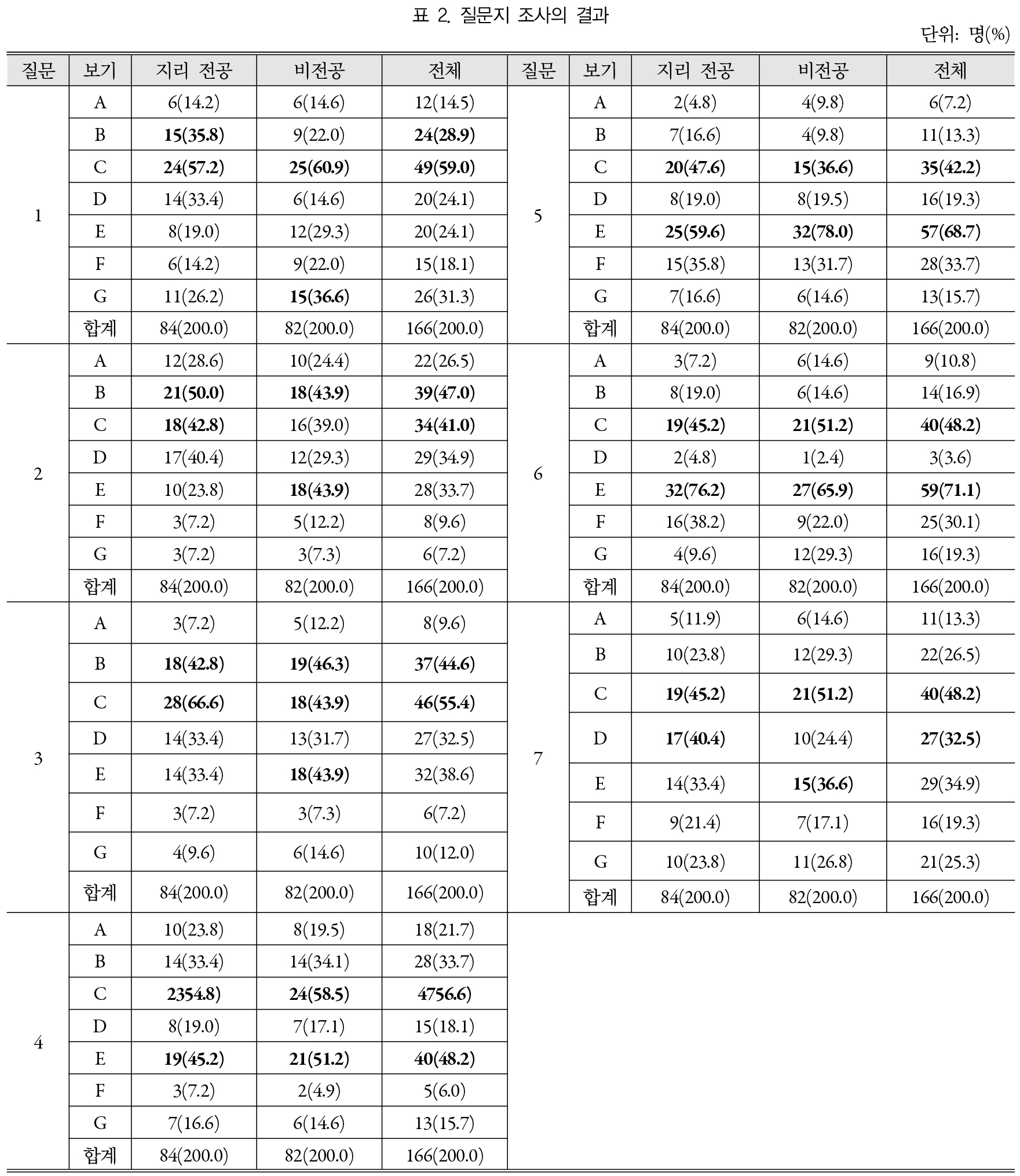
- This study explores strategies to revitalize primary geography education by strengthening its identity and systematization. Adopting a backward approach that values teachers’ voices, the study highlights three key findings. First, teachers—regardless of academic background—identify the lack of identity, systematization, and professionalism as key factors in the marginalization of primary geography education. They emphasize the need for research in the psychology of geography education and the dissemination of its results. Second, the psychology of geography education should be more clearly reflected in research literature and teacher guides, especially in general overviews and subject-specific units. There is a strong need for content grounded in domain-specific psychology. Third, the psychology of geography education should be more prominently integrated into both pre-service and in-service teacher training. In establishing and implementing such support systems, academic associations such as the Korean Association of Geographic and Environmental Education are expected to play a leading role. This study suggests that the revitalization of primary geography education depends on reinforcing the domain-specific psychology of geography education research and ensuring its practical relevance to classroom teaching.
- COLLAPSE
본 연구의 목적은 정체성과 체계성을 기반으로 한 초등지리교육의 활성화를 도모하기 위한 방안을 탐색하는 것이다. 본 연구는 현장적합성 높은 방안의 탐색을 위하여 교사들의 목소리를 존중하는 후향적 관점을 채택하였다. 본 연구의 주요한 연구결과와 시사점은 다음과 같다. 첫째, 현장교사들은 지리교육 전공 여부와 관계없이 초등지리교육의 비활성화 상태의 배경으로서 정체성, 체계화, 전문성의 미흡을 들고 있다. 비활성화를 극복하기 위해서는 지리교육심리의 연구와 그 결과의 보급이 가장 중요하다고 인식하고 있다. 둘째, 초등교사들이 교재연구와 수업의 구안을 위해서 가장 많이 활용하는 지리교육 연구서 및 사회과 교사용지도서의 총론과 지리단원 부분에서 지리교육심리가 중요하게 다루어질 필요가 있다. 특히 지리교육에 고유한 심리의 연구결과가 더욱 풍부하게 소개되어야 한다. 셋째, 초등지리교육심리가 초등교사의 양성과정, 현직연수과정에서 더욱 중요하게 제공되어야 한다. 이러한 지원체제의 구축과 실행에서 한국지리환경교육학회와 같은 전문 학술단체의 역할이 기대된다.
-
A Backward Approach to Activating Primary Geography Education - Focusing on the Teachers’ Voices -
-
Research Article
-
Meaning and Usefulness of Integrating Knowledge Method on a National Basis - As an Example of Russia -
국가 단위 지식 통합 방안의 의미와 유용성 - 러시아를 사례로 -
-
Sungwook Cho
조성욱
- In this study, the meaning and usefulness of the national-basis knowledge storage method were examined in Russia as an example. As a …
중등 교육과정의 세계지리 관련 지식들이 효과적으로 저장되고, 융합되어, 실생활에서의 문제해결이나 의사결정에 효율적으로 활용될 수 있는 방법으로, 국가 단위 지식저장 방법의 의미와 유용성을 …
- In this study, the meaning and usefulness of the national-basis knowledge storage method were examined in Russia as an example. As a way to effectively store and fuse knowledge related to world geography in the secondary curriculum and to effectively utilize it for real-life problem solving and decision-making. A limitation and problem of national recognition, first, despite having a lot of knowledge about a nation, it is difficult to integrate among knowledges because it is entered in pieces and cannot be interconnected. Second, it is difficult to effectively utilize knowledge because the contents learned for each subject are not collected and rearranged at the national basis. Third, knowledge is input by topic, so it is not effectively used to solve problems and make decisions about world problems based on national recognition. As an alternative, we looked at the three stages of input, storage, and utilization of knowledge as a method of integrating knowledge at a national basis. First, in the input stage of knowledge, the input knowledge and information can be reconstructed that can be used comprehensively when it is collected in one’s own recognition system and connected and fused. In the storage stage, the input information is reclassified and reconstructed to form its own perspective, and the elaboration and structuring process are carried out while qualitative changes are continuously made through changes in the schema. In the utilization stage, it is easier to withdraw from inter-nation problems from a national perspective, enabling quick problem recognition and decision-making, and speeding up the input, storage, and withdrawal process of new knowledge.
- COLLAPSE
중등 교육과정의 세계지리 관련 지식들이 효과적으로 저장되고, 융합되어, 실생활에서의 문제해결이나 의사결정에 효율적으로 활용될 수 있는 방법으로, 국가 단위 지식저장 방법의 의미와 유용성을 러시아를 사례로 살펴보았다. 먼저 국가 단위 인식의 한계와 문제점으로는, 첫째, 한 국가에 관한 많은 지식이 있음에도 불구하고 파편적으로 입력되어 상호 연결되지 못하여 지식 간의 융합이 어렵다. 둘째, 주제별로 학습한 내용이 국가 단위로 취합되고 재정리되지 못하여 지식의 효과적인 활용이 어렵다. 셋째, 지식들이 주제별로 입력되어 국가 단위 인식을 기본으로 하는 세계 문제의 문제해결이나 의사결정에 효율적으로 사용되지 못하고 있다. 이에 대한 대안으로 학습한 지식을 국가 단위로 통합하는 지식의 입력, 저장, 활용의 3단계 방법을 제시했다. 먼저 지식의 입력 단계에서는 입력된 지식과 정보는 자신의 인식 체계에 모여 연결 및 융합 작용이 이루어져야 종합적 활용이 가능한 수준으로 재구성될 수 있다. 저장 단계에서는 입력된 정보들은 재분류, 재구성되어 자신의 관점을 형성하게 되고, 스키마의 변화를 통해 계속적으로 질적인 변화를 하면서 정교화와 구조화 과정이 이루어진다. 활용 단계에서는 국가 간 문제에서 국가 단위의 관점으로 보다 쉽게 인출되어 빠른 문제인식과 의사결정이 가능해지고, 새로운 지식의 입력과 저장 그리고 인출과정을 빠르게 한다.
-
Meaning and Usefulness of Integrating Knowledge Method on a National Basis - As an Example of Russia -
-
Research Article
-
Spatial Justice Instruction and Its Educational Effects in the Integrated Society - Focusing on a Community-Based Spatial Justice Project -
「통합사회」에서의 공간 정의 수업과 교육적 효과 - 지역사회 공간 정의 프로젝트를 중심으로 -
-
Minsuk Son
손민석
- The purpose of this study was to design and implement a ‘community-based spatial justice project’ that applied the concept of spatial justice …
본 연구의 목적은 「통합사회」 과목에서 공간 정의 개념을 적용한 ‘지역사회 공간 정의 프로젝트’를 설계·적용하고, 그 교육적 효과를 분석하는 것이다. 이에 Soja의 공간 …
- The purpose of this study was to design and implement a ‘community-based spatial justice project’ that applied the concept of spatial justice within the high school subject Integrated Society and to analyze its educational effects. Accordingly, Soja’s concept of spatial justice was restructured, and its core elements (spatial equity, accessibility, rights, and redistribution) were derived and established as the foundation of learning, while the project was designed by incorporating inquiry strategies across disciplinary perspectives and the principles of spatial justice education. A total of 356 high school students participated in the project and, within the shared framework, carried out a variety of individual projects addressing spatial injustices in their local communities. Students investigated specific problems, analyzed their causes, and explored and implemented potential solutions to promote spatial justice. The educational effects were analyzed using a mixed-methods approach. Quantitative analysis revealed statistically significant improvements across all four domains of spatial justice, while qualitative findings indicated not only an enhanced understanding of spatial justice, but also growth in integrated thinking, civic awareness, and critical thinking. This study demonstrates that spatial justice can be effectively taught in the classroom and that students can critically engage in spatial injustice and develop practical strategies for promoting spatial justice as active citizens.
- COLLAPSE
본 연구의 목적은 「통합사회」 과목에서 공간 정의 개념을 적용한 ‘지역사회 공간 정의 프로젝트’를 설계·적용하고, 그 교육적 효과를 분석하는 것이다. 이에 Soja의 공간 정의 개념을 재구성하고 핵심 요소(공간적 형평성·접근성·권리·재분배)를 도출하여 학습의 중심축으로 설정하고, 교과 관점별 탐구 전략과 공간 정의 교육 원리를 반영하여 프로젝트를 설계하였다. 프로젝트에는 356명의 고등학생이 참여하였고, 이들은 지역사회의 다양한 공간 부정의 문제를 조사·분석하고, 공간 정의 실현을 위한 해결 방안을 탐색·실천하는 활동을 수행하였다. 교육적 효과는 혼합 연구 방법을 통해 분석하였으며, 정량적 분석 결과, 공간적 형평성·접근성·권리·재분배 모든 영역에서 통계적으로 유의미한 변화가 나타났다. 정성적 분석 결과, 공간 정의의 이해도 향상뿐만 아니라, 통합적 관점 형성, 시민성 함양, 비판적 사고력 함양 등 다양한 효과가 보고되었다. 본 연구는 학교 현장에서 공간 정의를 활용한 교육이 가능하며, 학생들이 시민으로서 공간 부정의 문제를 통합적으로 탐구하고 공간 정의 실현 전략을 모색 및 실천하도록 이끌 수 있음을 입증한 데 의의가 있다.
-
Spatial Justice Instruction and Its Educational Effects in the Integrated Society - Focusing on a Community-Based Spatial Justice Project -
-
Research Article
-
Innovative Geography Education through the 25th World Scout Jamboree - From Jeonbuk Jamboree Map to Youth Diplomacy -
제25회 세계잼버리대회를 통한 혁신적 지리교육 - 전북 잼버리 지도에서 청소년 공공외교로 -
-
Eje Kim
김이재
- This study explores the planning, development, and implementation of an education program designed to enrich the geographical experience of over 40,000 youth …
세계잼버리대회는 전 세계 청소년이 대규모로 모이는 교육의 장이자 국제교류의 잠재력을 지닌 국제 행사이다. 본 논문은 2023년 8월 새만금 야영장에서 개최된 제25회 세계잼버리대회에 …
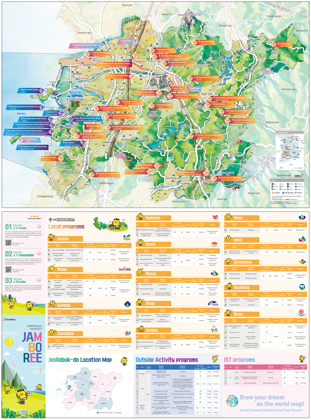
- This study explores the planning, development, and implementation of an education program designed to enrich the geographical experience of over 40,000 youth from more than 150 countries who participated in the 25th World Scout Jamboree held in Jeonbuk State, South Korea, in August 2023. The World Scout Jamboree serves as a unique educational platform and a venue for global youth’s international exchange. The program integrates connectography-based educational activities, an interactive “Jamboree Map” utilizing IoT technology, and 35 experiential programs across the 14 cities and counties of Jeonbuk State. Although the chaotic operation of the event posed limitations for on-site implementation, the study focuses on post-event initiatives, including the development of online platforms and the use of visual materials to contextualize participants’ geographical experiences and deepen their understanding of Korea. Furthermore, the study examines the potential for expanding youth-led public diplomacy through fieldwork and school visits in Gunsan, Jeonju, and Gochang, in conjunction with the GG Summer School. This case demonstrates how international mega-events can serve as catalysts for innovative geography education and intercultural engagement.
- COLLAPSE
세계잼버리대회는 전 세계 청소년이 대규모로 모이는 교육의 장이자 국제교류의 잠재력을 지닌 국제 행사이다. 본 논문은 2023년 8월 새만금 야영장에서 개최된 제25회 세계잼버리대회에 참여한 150여 개국 4만여 명의 청소년을 대상으로, 전북특별자치도의 자연 및 인문환경을 효과적으로 소개하는 교육 프로그램을 기획·개발한 과정을 분석하고 그 시사점을 도출하고자 한다. 2023년 세계잼버리대회는 운영상의 혼란으로 사전에 개발한 교육 프로그램을 현장에서 온전히 적용하지 못하는 한계가 있었지만, 이후 온라인 플랫폼 구축과 시각 자료 및 영상을 활용한 다양한 교육활동을 통해 참가 청소년들의 전북특별자치도에서의 지리적 경험을 맥락화시키는 교육 프로그램 연구가 진행되었다. 특히 커넥토그래피 기반의 국제교류 활동, 사물인터넷(IoT) 기술을 접목한 전북 잼버리 지도, 전북 14개 시군에서 운영된 35개 체험활동 및 영외 교육 프로그램을 중심으로 논의한다. 아울러 GG 서머스쿨과 연계한 군산, 전주, 고창 지역의 필드워크 및 학교 방문 프로그램을 통해 청소년 주도의 국제교류와 공공외교로의 확장 가능성도 함께 모색하였다.
-
Innovative Geography Education through the 25th World Scout Jamboree - From Jeonbuk Jamboree Map to Youth Diplomacy -
-
Research Article
-
Curriculum Improvement Strategies for Enhancing the Digital Competencies of Pre-service Geography Teachers
예비 지리교사의 디지털 역량 함양을 위한 교육과정 개선 방안
-
Eunju Kwon
권은주
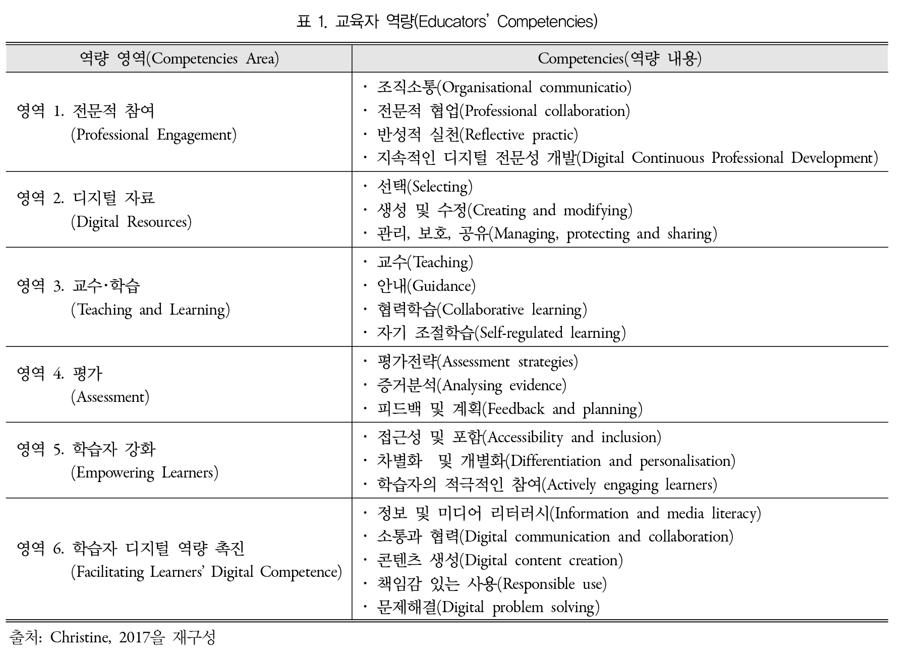
- This study explores curriculum improvement strategies within teacher education programs to foster digital competencies among pre-service geography teachers in response to the …
본 연구는 생성형 AI의 등장 및 디지털 기술의 급속한 발달에 대응하여, 예비 지리교사의 디지털 역량을 함양하기 위한 교사양성과정에서의 교육과정 개선 방안을 모색하였다. …
- This study explores curriculum improvement strategies within teacher education programs to foster digital competencies among pre-service geography teachers in response to the emergence of generative AI, the rapid advancement of digital technologies. Despite growing demands for personalized education and the adoption of AI digital textbooks, current teacher education curricula have not sufficiently addressed the instructional needs of digital-based teaching. To respond to this gap, the study draws on international frameworks—including the DigiCompEdu Framework (EU), ISTE Standards (USA), and UNESCO’s AI Competency Framework for Teachers—to identify five core areas of digital competence required for educators: the use and creation of digital resources, digital lesson design and implementation, digital assessment and learning analytics, digital citizenship and ethical responsibility, and professional development and adaptability to change. Based on these competencies, the study proposes the introduction of a new practice-oriented course titled “Digital Geography Pedagogy (tentative title),” designed to provide pre-service geography teachers with structured experiences in designing, implementing, and evaluating AI- and digitally-enhanced lessons. Through this course, pre-service teachers can build the professional capacity to respond proactively to evolving educational environments.
- COLLAPSE
본 연구는 생성형 AI의 등장 및 디지털 기술의 급속한 발달에 대응하여, 예비 지리교사의 디지털 역량을 함양하기 위한 교사양성과정에서의 교육과정 개선 방안을 모색하였다. 최근 AI 디지털 교과서 도입과 개인 맞춤형 교육에 대한 요구가 높아지고 있음에도 불구하고, 현재 교사양성과정은 디지털 기반 수업에 대한 요구를 충분히 반영하지 못하고 있다. 이에 본 연구는 DigiCompEdu Framework(EU), ISTE Standards(미국), UNESCO AI CFT 등 국제 기준을 바탕으로, 교사에게 요구되는 다섯 가지 디지털 역량( ‘디지털 자료 활용·생성’, ‘디지털 수업 설계·실행’, ‘디지털 평가 및 분석’, ‘디지털 시민성과 윤리적 책임’, ‘디지털 전문성 개발과 변화 대응’)을 도출하였다. 그리고 이러한 역량이 교사양성과정에서부터 체계적으로 길러질 수 있도록 ‘디지털 지리교수법(가칭)’과목의 신설을 제안하였다. 본 과목은 예비 지리교사가 AI·디지털 도구를 활용하여 수업을 설계·실행·평가하는 전 과정을 경험하고 성찰하도록 구성하여, 변화하는 교육환경에 능동적으로 대응할 수 있는 전문성을 기르도록 하였다. 이와 더불어 지리교육 맥락에 적합한 디지털 교수·학습 방법의 구체적 방향을 제시함으로써 교사양성과정의 교육과정 개선에 기여하고자 한다.
-
Curriculum Improvement Strategies for Enhancing the Digital Competencies of Pre-service Geography Teachers

Journal Informaiton
 The Journal of The Korean Association of Geographic and Environmental Education
The Journal of The Korean Association of Geographic and Environmental Education


한국지리환경교육학회
(06639) 96 Seochojungang-ro, Seocho-gu, Seoul (1650 Seocho-dong) Seoul National University of Education
Tel: +82-2-3475-2436 / E-mail: kageeedit@naver.com Copyright© The Korean Association Of Geographic And Environmental Education. Powered by APUB
Tel: +82-2-3475-2436 / E-mail: kageeedit@naver.com Copyright© The Korean Association Of Geographic And Environmental Education. Powered by APUB